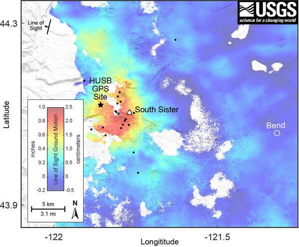
Satellite radar interferogram covering June 19, 2020, to August 13, 2021, and depicting ground motion in the direction of the satellite. Small pulses of magma collecting around 4 miles (7 km) below the earth surface are thought to be responsible for the uplift.
The maximal uplift, shown by the red tint, is about 2.2 centimeters (0.85 inches) and is positioned west of South Sister.
The huge dark dot indicates the HUSB continuous GPS station.
Earthquakes that happened within the interferogram’s time frame are shown by little black dots.
USGS satellite radar interferogram from June 19, 2020, to August 13, 2021, showing ground motion in the direction of the satellite.

The maximal uplift, shown by the red tint, is about 2.2 centimeters (0.85 inches) and is positioned west of South Sister.
The huge dark dot indicates the HUSB continuous GPS station. Earthquakes that happened within the interferogram’s time frame are shown by little black dots.
A minor, but visible by satellite, uplift near the South Sister volcano is making headlines again, this time with a faster pace of rising ground than observed in years, followed by several small but discernible, shallow earthquakes.
Will There Be a Volcano Eruption?
Even there are telling clues, the scientists promise that an eruption is not on the horizon anytime soon.
The following is the newest press release from the US Geological Survey, which was released on Monday:
Cascades Volcano Observatory geophysicists have discovered a modest rise in the rate of ground surface uplift around 3 miles (5 km) west of South Sister volcano in Oregon using satellite photos and sophisticated GPS sensors. Increased uplift has already been reported in this location, and the volcano’s warning level and color code remain NORMAL / GREEN.
Data from satellite radar photos suggest that an uplift of around 0.9 inches or 2.2 cm (about the breadth of an adult’s thumb) happened throughout a 12-mile (20-kilometer) radius during the summers of 2020 and 2021. Since August 2021, GPS data from a volcano monitoring site near the center of uplift have indicated at least 0.2 inches (0.5 cm) of elevation.
Seismologists also recorded short bursts of minor earthquakes in October 2021, December 2021, and January 2022. The majority of these shallow earthquakes are too tiny to be accurately pinpointed; those that are found are inside the raised region.
In the mid-1990s, there was an uplift in the same approximate area. During the 25 years between 1995 and 2020, the area increased at its center by roughly 12 inches or 30 cm -the height of a 2-liter soda bottle.
Although the present rate of uplift is less than the greatest rate documented in 1999-2000, it is much quicker than the rate seen for many years before to 2020.
Small pulses of magma collecting around 4 miles (7 km) below the earth surface are thought to be responsible for the uplift.
While any magmatic intrusion might ultimately result in a volcanic eruption, such an eruption would most likely be preceded by noticeable and more violent earthquakes, ground movement -deformation- and geochemical changes.
In general, when magma rises during an intrusion, it produces ongoing or accelerated uplift, cracks rock, causing swarms of earthquakes, and emits considerable volumes of volcanic gases such as carbon dioxide.
Scientists are presently not detecting any of these signals.
CVO experts will constantly monitor data in the next months and provide further updates as needed.


Leave a Reply